

Located at: 17724 Interstate 30 Suite 5A
Benton, Arkansas 72019
Phone: (501) 315-9009
email: bruceshackleford@aristotle.net
Benton, Arkansas 72019
Phone: (501) 315-9009
email: bruceshackleford@aristotle.net
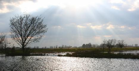
WOOLSEY WET PRAIRIE SANCTUARY RESTORATION PROJECT
The Woolsey Wet Prairie Sanctuary was established by the City of Fayetteville as part of a wetland
compensatory mitigation requirements under Section 404 Permit 14207 by the U.S. Army Corps of
Engineers Little Rock District. The 28-acre mitigation site was constructed to offset the permanent
alteration of 9.88 acres of wetlands from construction of the City's Wastewater Systems Improvement
Project (WSIP). Hydrological modifications were made by the construction of earthen berms to create a
mix of habitats such as wet meadow wetlands, marsh and open water habitat, and forested wetlands.
Design work was a joint effort of ecologists from Environmental Consulting Operations, Inc., and
engineers from McGoodwin, Williams, and Yates Consulting Engineers, Inc.
The site, originally a tall grass wet prairie, still has intact upland prairie mounds that appear to have
never been subjected to plowing, and depressional areas between mounds where water seasonably
ponds forming wetlands. Such prairie mounds and wet prairie depressions were common in the area
prior to the western expansion by settlers in the early to mid 1800's. Recognizing that this is a very rare
and endangered natural resource in northwest Arkansas, the designers developed a wetland mitigation
strategy with the objective of restoring the natural prairie ecosystem that once existed on the site.
Plant ecologists universally agree that today, prairie is the rarest and most fragmented of North
American ecosystems, and the one most in danger of being lost completely. Tall grass prairies once
extended from Manitoba to the Texas Coast and eastward into Indiana. Today, only 2,000 acres (only
one percent) of the original two million acres of tall grass prairie in this region of the country are as yet
unplowed. Decades of crop farming, cattle grazing, mowing for hay, fire suppression, introduction of
non-native plant species, and drainage ditches, have contributed to the pre-restoration degraded
condition of the Woolsey Wet Prairie Sanctuary. Such land uses reduced native prairie grasses and
allowed invasive plant species; including fescue, ryegrass, velvet grass, bromegrass, ragweed,
Japanese honeysuckle, sumac, blackberry, sassafras, and persimmon; to overtake native plant species
as community dominants.
The Woolsey Wet Prairie Sanctuary is part of the original prairie of Prairie Township, Fayetteville,
Arkansas that extended all the way to the Prairie Grove and Lincoln areas in Washington County.
Conservation of an estimated 100,000 acres of prairie habitat to the production of wheat in northwest
Arkansas in the late 1800's and early 1900's was the beginning of the decimation of prairie habitat.
Soils and Geology
The Woolsey Wet Prairie Sanctuary is a 28-acre remnant of a tall grass prairie that is a part of the
original Osage Prairie on the Springfield Plateau west of the White River/Illinois River Divide. Soils are
Taloka complex mounded, which are composed of shallow depressions of sandy loam that are
underlain by a fragi-pan of impervious clay. The depressions retain water for extended periods after
rainfall, providing a competitive edge for grasses over trees and producing wetland prairie habitat.
Prairie mounds or “pimples” scattered throughout area are small hummocks five to fifteen feet in
diameter and one to four feet in elevation. During the much colder temperatures of the Cenozoic Era,
about 65 million years ago, glaciers covered much of North America. A warmer drier period, followed
this Ice Age, and vegetation in Arkansas resembled that found in more arid parts of the world. Clumps
of vegetation were surrounded by dry, bare ground, and wind-blown dust filled the vegetation clumps,
creating the mounds that are visible today on the Woolsey Wet Prairie Sanctuary.
Prairie Plant Communities
Tall grass prairies are open grasslands with scattered forbs, shrubs and trees that exhibit a gradation in
community species composition related to the degree of soil moisture. There are different plant species
found on upland mounds than within wetland depressions, as well as unique plant communities within
transition zones between upland mounds and wetland depressions. Examples of gradation in species
composition include a gradual transition from dry (little bluestem) to mesic (big bluestem) to hydric
species (switchgrass and buttonbush). Plant community associations such as big bluestem, little
bluestem, switchgrass, Indiangrass, prairie cordgrass, gayfeather, forbs, perennial legumes, and other
perennials are indicative of natural prairie conditions.
Historical Regional Wildlife and Settlement
After the Louisiana Purchase in 1803, many explorers, both private and government-funded, set out to
learn about the physical and human geography of this new acquisition. The land and people of
Arkansas were a part of this study.
From November 1818 to February 1819, Henry Rowe Schoolcraft and a companion, Levi Pettibone,
made an expedition from Missouri to the White River, and Osage Creek regions of northwest Arkansas,
surveying the geography, geology, and mineralogy of the area. Schoolcraft published his journal from
this trip, Journal of a Tour into the Interior of Missouri and Arkansaw (1821) that was the first written
account of an exploration of the Ozarks and tallgrass prairies of northwest Arkansas. He described in
detail villages of Delaware, Shawanees, and Osage Indians. At that time, portions of northwest
Arkansas did not have the large expanses of hardwood forests as it does today. As Schoolcraft wrote:
“Our route this day has been over barrens and prairies, with occasional forests of oak, the soil poor, and
covered with grass, with very little under-brush. One of the greatest inconveniences we experience in
travelling in this region, arises from the difficulty of finding, at the proper time, a place of encampment
affording wood and water, both of which are indispensable.”
“This is a difficulty which attends us this evening, having been compelled to stop in an open prairie,
where wood is very scarce, and the water bad-general course of traveling south-weather pleasant, the
rain having ceased shortly after day-light. Lands poor; trees, oaks; game observed, deer and elk.”
“In calling this a high- land prairie, I am to be understood as meaning a tract of high-land generally level,
and with very little wood or shrubbery. It is a level woodless barren covered with wild grass, and
resembling the natural meadows or prairies of the western country in appearance……..The
inducements for hunting are, however, great; and large quantities of bear, deer, elk, and beaver skins,
might be collected.”
“The prairies, which commence at the distance of a mile west of this river, are the most extensive, rich,
and beautiful, of any which I have ever seen west of the Mississippi river. They are covered by a coarse
wild grass, which attains so great a height that it completely hides a man on horseback in riding through
it. The deer and elk abound in this quarter, and the buffaloe is occasionally seen in droves upon the
prairies, and in the open high-land woods.”
In 1819, naturalist Thomas Nuttall journeyed through the Arkansas Territory and documented a “vast and
trackless wilderness of trees” and “great prairies and canebrakes”. Bison, eastern elk, swans,
passenger pigeons, ruffed grouse, and prairie chickens were among the abundant wildlife populations
that still made their homes in the Arkansas Territory during this time. Not long thereafter, however, as
the territory became settled, species began to disappear. Less than a century after Nuttall’s journey
through Arkansas, little remained of the virgin upland and bottomland forests and tall grass prairies.
Transportation routes opened the flow of western expansion and eventually into northwest Arkansas. In
1827, a wagon road was completed between Memphis, Tennessee and Little Rock, Arkansas by the U.
S. Army Corps of Engineers. Soon thereafter, a second road to Fort Smith followed, as well as others
into northwest Arkansas. The travel routes, called military roads, were the beginnings of commercial
and political passages among the regions, and prepared the Arkansas Territory for statehood. Formerly
accessible to only a few hardy trappers and explorers, the land was now was opened to settlement.
By the mid-1800’s, a vast land grab was on. In 1849 and 1850, Congress passed The Swamp Land
Acts that led to the selling of 8.6 million acres of federally owned land (one-quarter of the state) to a
state Board of Swampland Commissioners at a price of $1.25 per acre. This created a new surge of
people into and through Arkansas, some as a part of the California Gold Rush, causing many more
miles of dirt roads to appear. More people resulted in new demands for flood control in eastern
Arkansas, resulting in improved overland access into the mountains of northwest Arkansas. During the
1860s, an Office of Commissioner of Public Works was established to construct levees across the
Arkansas Delta to prepare for the construction of railroads. By 1873, Arkansas had 300 miles of
railroad track.
The wanton exploitation of natural resources prevailed during this pre-resource conservation and
management era. The more accessible forests were rapidly cut by timber companies, and by the late
1870s, the incredibly rich pine and hardwood forests of Arkansas were gone. High quality cherry and
walnut trees and old growth white oak and pine existed only in the most remote locations. One-crop
farming, primarily of cotton and wheat, further devastated timberlands and prairies. Farmers moved
from one forty-acre plot to the next, as soils quickly became depleted.
With the destruction of forest and prairie habitats, so went the wildlife that once thrived in the area. The
eastern elk (Cervus elaphus canadensis) lived in eastern hardwood forests and prairies, and was native
to northwest Arkansas. Historical accounts indicate elk were the first game species to be killed out,
having vanished from the region by the 1840’s, and becoming extinct soon thereafter. American bison
herds were common to northwest Arkansas tall grass prairies. Before 1870, none were left in
Arkansas. Packs of gray wolves that often followed bison herds were exterminated from Arkansas after
the beginning of the 20th century, and the red wolf disappeared by 1950.
Numerous references can be found to the ruffed grouse, (Bonasa umbellus), locally known as the “wood
hen”, within 19th century pioneer literature of northwest Arkansas. Extensive logging activities
eliminated critical habitat for this bird, which disappeared from the region around 1900. As noted by
Professor F. L. Harvey of the University of Arkansas it was considered “very scarce” in the Fayetteville
area in 1883.
The greater prairie-chicken, (Tympanuchus cupido) was a common resident in the open grasslands of
the western Arkansas Ozarks. The last known specimen in Arkansas was killed within one mile of the
Woolsey Wet Prairie Sanctuary in 1917.
Hunting pressure and the conversion of an estimated 100,000 acres of grassland habitat to production
of wheat in northwest Arkansas in the late 1800’s and early 1900’s were responsible for the loss of this
species.
The passenger pigeon (Ectopistes migratorius) occurred in Arkansas as a migrant and winter resident
by the millions. Their flocks, a mile wide and up to 300 miles long, were so dense that they darkened the
sky for hours and days as the flock passed overhead. North America population estimates from the
19th century ranged from 1 billion to close to 4 billion individuals. Total populations may have reached 5
billion individuals and comprised up to 40% of the total number of birds in North America, making them
the most abundant bird on the planet.
Professor F. L. Harvey of the University of Arkansas reported it to be very plentiful during the winter of
1883 at Fayetteville. The extreme northwest corner of Arkansas was the last known stronghold of these
birds, prior to their extinction. In less than 20 years, the wanton slaughter of literally wagon loads of
birds at roosting sites by the use of guns, clubs, and nets for table fare, totally exterminated this species.
This is possibly the only species for which the exact time of extinction is known. The last Passenger
Pigeon, named Martha, died at the Cincinnati Zoo at 1:00 pm on September 1, 1914.
To the West of 19th Century Fayetteville, 2,000 passenger pigeons were netted by one man in a short
period of time and shipped to Boston. The last known shipments of the bird were reportedly received by
a game dealer in St. Louis from Siloam Springs around 1893, and another as late as 1901 when 12
dozen pigeons were shipped from Rogers. The last documented passenger pigeon killed in Arkansas,
was shipped from Rogers as a museum specimen in 1902.
The Carolina parakeet (Conuropsis carolinensis) once inhabited northwest Arkansas, and was
considered to be a pest, due to its strong preference for fruit, a common cash crop of this period. This
led to mass killings in orchards that were easily accomplished, due to their gregarious nature. As each
bird was killed, others would hover over their dead companions, screaming until they too were killed.
The last known Carolina parakeet to be killed in the region was taken in Oklahoma in 1886. By 1901,
this species was extirpated from the wild. In 1918, the last captive Carolina parakeet, named “Incas”
died in captivity in the Cincinnati Zoological Garden, within a year of his mate "Lady Jane."
Map based upon the original U.S. Government Land Survey Records 1831-1838
Woolsey Family History
The Woolsey Wet Prairie Sanctuary is named after, and was a part of, the original farm settled in 1830
by Samuel Gilbert Woolsey (1791-1858) and his wife, Matilda (1794-1871) only two years after
Washington County was formed, and six years before Arkansas achieved statehood. Samuel Woolsey
was born and raised on a Kentucky farm, and grew into manhood as a noted hunter and scout. In 1808,
he lived for a period of time in Missouri, later marrying Matilda Thompson about 1810 in Illinois. After
Samuel served in the War of 1812, he moved his family to Hempstead County, Arkansas in 1814, and
later moved to the homestead on this property owned by the City of Fayetteville in 1830. Undoubtedly,
the elk, bison, prairie chickens, passenger pigeon, ruffed grouse, and Carolina parakeet were
commonplace in the frontier life known by the Woolsey family.
The Woolsey’s participated with four other couples to form the Farmington Ebenezer Methodist Church
in 1833. A building plot was offered by the Kinnibrugh couple and a small log building was erected with
one door and a window, split log benches and one song book Mrs. Kinnibrugh brought from Virginia.
The singing was read line by line and led by the song leader. A Circuit Rider came once each month for
church services or for memorial services for those who died during the month.
Being a War of 1812 veteran is most likely the reason the Woolsey’s came to northwest Arkansas.
Veterans of the War of 1812 received quarter sections of prairie land in Arkansas as compensation for
war duty. Together, Samuel and Matilda had thirteen children, some of who are buried at the Woolsey
Cemetery located on this property with their parents.
Bringing Back The Past
Restoration tools for “bringing back the prairie ecosystem of the past” include preservation of the
microtopography (mounds and depressions), construction of earthen berms as hydrological controls to
offset man-made drainage ditches and the original construction of Broyles Road, seeding of native
vegetation, herbicides, and controlled burning to simulate pre-settlement natural environmental
conditions. This is a step by step cause and effect process, called “adaptive management” whereby
each tool is not employed until after reviewing the results of the previous tool(s).
Drainage ditches reduced the original wet prairie acreage, and decades of fire suppression,
introduction of non-native invasive plants, overgrazing, and over-haying created a severely degraded
prairie remnant.
Where are we now?
Plant Species Inventory
2001-2005 - 47 species
Cattle Removed from site May 2006
Berm construction completed July 2006
August 2006 - 166 species
May 2007 - 265 species
August 2007 – 278 species
September 2008 – 325 species
November 2008 - 334 species
All With No Seeding!!!!!!!!!!
Native plant seeds can lie dormant for more than 50 years, until conditions conducive to their
germination and growth are created.
We have observed seven plant species of special concern (never before identified in Washington
County) that are tracked by the Arkansas Natural Heritage Commission.
They include:
1) Carex opaca – opaque prairie sedge
Washington County record; previously found only in two other counties in eastern Arkansas.
2) Carex pellita – wooly sedge
Washington County record; previously found only at one known location in Lawrence County in
northeastern Arkansas.
3) Eleocharis wolfii – Wolf’s spikerush
Washington County record; previously found only in three other counties in southern Arkansas.
4) Rhynchospora macrostachya – tall-horned beaksedge
Washington County record; previously found only in four other counties in western Arkansas.
5) Scleria pauciflora – drooping bulrush
Washington County record; previously found only in five other counties in Arkansas.
6) Carex arkansana – Arkansas sedge
Washington County record; previously found only in one other county in Arkansas.
7) Carex fissa – hammock sedge
Washington County record; previously found only in one other county in Arkansas.
“Build it, and they will come!”
PHASE II - PROPOSED WOOLSEY WET PRAIRIE SANCTUARY
MITIGATION BANK
Types of Mitigation Banks; can be for wetland mitigation, and/or stream mitigation.
Nationwide, there are 66 single-client banks.
There are five single-client banks in Arkansas, four of which are AHTD, and one is private industry.
There are no “Municipally-Owned” “Single-Client” banks in Arkansas. The City of Fayetteville will be the
first of this kind.
MITIGATION BANK PRELIMINARY EVALUATION SCOPE
Task 1 – Develop Mitigation Bank Prospectus
Task 2 – Submit Prospectus to City
Task 3 – Submit Prospectus to Corps
• Submit Prospectus to Corps
• Meet with Corps and discuss any changes to prospectus that may be needed for better
presentation to Multi-Agency Wetland Planning Team
Task 4 – Meet with MAWPT
The Arkansas Multi-Agency Wetland Planning Team (MAWPT) comprises state agency representatives
promoting wetland conservation through implementation of goals and objectives contained in the
Arkansas Wetland Strategy. The Arkansas MAWPT, formed through the Governor's office, has
developed statewide and watershed level strategies that encourage voluntary, incentive-based
conservation initiatives and consistent planning efforts. MAWPT is composed of individuals from the
following agencies:
• Arkansas Soil & Water Conservation Commission
• Arkansas Natural Heritage Commission
• Arkansas Forestry Commission
• Arkansas Cooperative Extension Service
• Arkansas Game and Fish Commission
• Arkansas Department of Environmental Quality
ADVANTAGES OF EXPANDING WWPS
1) Cost-Effectiveness Benefits
2) Aesthetic and Environmental Benefits
Systems Improvement Project.
WWPS FOUNDATION
Conceptual Aerial of Proposed Mitigation Bank
The Woolsey Wet Prairie Sanctuary was established by the City of Fayetteville as part of a wetland
compensatory mitigation requirements under Section 404 Permit 14207 by the U.S. Army Corps of
Engineers Little Rock District. The 28-acre mitigation site was constructed to offset the permanent
alteration of 9.88 acres of wetlands from construction of the City's Wastewater Systems Improvement
Project (WSIP). Hydrological modifications were made by the construction of earthen berms to create a
mix of habitats such as wet meadow wetlands, marsh and open water habitat, and forested wetlands.
Design work was a joint effort of ecologists from Environmental Consulting Operations, Inc., and
engineers from McGoodwin, Williams, and Yates Consulting Engineers, Inc.
The site, originally a tall grass wet prairie, still has intact upland prairie mounds that appear to have
never been subjected to plowing, and depressional areas between mounds where water seasonably
ponds forming wetlands. Such prairie mounds and wet prairie depressions were common in the area
prior to the western expansion by settlers in the early to mid 1800's. Recognizing that this is a very rare
and endangered natural resource in northwest Arkansas, the designers developed a wetland mitigation
strategy with the objective of restoring the natural prairie ecosystem that once existed on the site.
Plant ecologists universally agree that today, prairie is the rarest and most fragmented of North
American ecosystems, and the one most in danger of being lost completely. Tall grass prairies once
extended from Manitoba to the Texas Coast and eastward into Indiana. Today, only 2,000 acres (only
one percent) of the original two million acres of tall grass prairie in this region of the country are as yet
unplowed. Decades of crop farming, cattle grazing, mowing for hay, fire suppression, introduction of
non-native plant species, and drainage ditches, have contributed to the pre-restoration degraded
condition of the Woolsey Wet Prairie Sanctuary. Such land uses reduced native prairie grasses and
allowed invasive plant species; including fescue, ryegrass, velvet grass, bromegrass, ragweed,
Japanese honeysuckle, sumac, blackberry, sassafras, and persimmon; to overtake native plant species
as community dominants.
The Woolsey Wet Prairie Sanctuary is part of the original prairie of Prairie Township, Fayetteville,
Arkansas that extended all the way to the Prairie Grove and Lincoln areas in Washington County.
Conservation of an estimated 100,000 acres of prairie habitat to the production of wheat in northwest
Arkansas in the late 1800's and early 1900's was the beginning of the decimation of prairie habitat.
Soils and Geology
The Woolsey Wet Prairie Sanctuary is a 28-acre remnant of a tall grass prairie that is a part of the
original Osage Prairie on the Springfield Plateau west of the White River/Illinois River Divide. Soils are
Taloka complex mounded, which are composed of shallow depressions of sandy loam that are
underlain by a fragi-pan of impervious clay. The depressions retain water for extended periods after
rainfall, providing a competitive edge for grasses over trees and producing wetland prairie habitat.
Prairie mounds or “pimples” scattered throughout area are small hummocks five to fifteen feet in
diameter and one to four feet in elevation. During the much colder temperatures of the Cenozoic Era,
about 65 million years ago, glaciers covered much of North America. A warmer drier period, followed
this Ice Age, and vegetation in Arkansas resembled that found in more arid parts of the world. Clumps
of vegetation were surrounded by dry, bare ground, and wind-blown dust filled the vegetation clumps,
creating the mounds that are visible today on the Woolsey Wet Prairie Sanctuary.
Prairie Plant Communities
Tall grass prairies are open grasslands with scattered forbs, shrubs and trees that exhibit a gradation in
community species composition related to the degree of soil moisture. There are different plant species
found on upland mounds than within wetland depressions, as well as unique plant communities within
transition zones between upland mounds and wetland depressions. Examples of gradation in species
composition include a gradual transition from dry (little bluestem) to mesic (big bluestem) to hydric
species (switchgrass and buttonbush). Plant community associations such as big bluestem, little
bluestem, switchgrass, Indiangrass, prairie cordgrass, gayfeather, forbs, perennial legumes, and other
perennials are indicative of natural prairie conditions.
Historical Regional Wildlife and Settlement
After the Louisiana Purchase in 1803, many explorers, both private and government-funded, set out to
learn about the physical and human geography of this new acquisition. The land and people of
Arkansas were a part of this study.
From November 1818 to February 1819, Henry Rowe Schoolcraft and a companion, Levi Pettibone,
made an expedition from Missouri to the White River, and Osage Creek regions of northwest Arkansas,
surveying the geography, geology, and mineralogy of the area. Schoolcraft published his journal from
this trip, Journal of a Tour into the Interior of Missouri and Arkansaw (1821) that was the first written
account of an exploration of the Ozarks and tallgrass prairies of northwest Arkansas. He described in
detail villages of Delaware, Shawanees, and Osage Indians. At that time, portions of northwest
Arkansas did not have the large expanses of hardwood forests as it does today. As Schoolcraft wrote:
“Our route this day has been over barrens and prairies, with occasional forests of oak, the soil poor, and
covered with grass, with very little under-brush. One of the greatest inconveniences we experience in
travelling in this region, arises from the difficulty of finding, at the proper time, a place of encampment
affording wood and water, both of which are indispensable.”
“This is a difficulty which attends us this evening, having been compelled to stop in an open prairie,
where wood is very scarce, and the water bad-general course of traveling south-weather pleasant, the
rain having ceased shortly after day-light. Lands poor; trees, oaks; game observed, deer and elk.”
“In calling this a high- land prairie, I am to be understood as meaning a tract of high-land generally level,
and with very little wood or shrubbery. It is a level woodless barren covered with wild grass, and
resembling the natural meadows or prairies of the western country in appearance……..The
inducements for hunting are, however, great; and large quantities of bear, deer, elk, and beaver skins,
might be collected.”
“The prairies, which commence at the distance of a mile west of this river, are the most extensive, rich,
and beautiful, of any which I have ever seen west of the Mississippi river. They are covered by a coarse
wild grass, which attains so great a height that it completely hides a man on horseback in riding through
it. The deer and elk abound in this quarter, and the buffaloe is occasionally seen in droves upon the
prairies, and in the open high-land woods.”
In 1819, naturalist Thomas Nuttall journeyed through the Arkansas Territory and documented a “vast and
trackless wilderness of trees” and “great prairies and canebrakes”. Bison, eastern elk, swans,
passenger pigeons, ruffed grouse, and prairie chickens were among the abundant wildlife populations
that still made their homes in the Arkansas Territory during this time. Not long thereafter, however, as
the territory became settled, species began to disappear. Less than a century after Nuttall’s journey
through Arkansas, little remained of the virgin upland and bottomland forests and tall grass prairies.
Transportation routes opened the flow of western expansion and eventually into northwest Arkansas. In
1827, a wagon road was completed between Memphis, Tennessee and Little Rock, Arkansas by the U.
S. Army Corps of Engineers. Soon thereafter, a second road to Fort Smith followed, as well as others
into northwest Arkansas. The travel routes, called military roads, were the beginnings of commercial
and political passages among the regions, and prepared the Arkansas Territory for statehood. Formerly
accessible to only a few hardy trappers and explorers, the land was now was opened to settlement.
By the mid-1800’s, a vast land grab was on. In 1849 and 1850, Congress passed The Swamp Land
Acts that led to the selling of 8.6 million acres of federally owned land (one-quarter of the state) to a
state Board of Swampland Commissioners at a price of $1.25 per acre. This created a new surge of
people into and through Arkansas, some as a part of the California Gold Rush, causing many more
miles of dirt roads to appear. More people resulted in new demands for flood control in eastern
Arkansas, resulting in improved overland access into the mountains of northwest Arkansas. During the
1860s, an Office of Commissioner of Public Works was established to construct levees across the
Arkansas Delta to prepare for the construction of railroads. By 1873, Arkansas had 300 miles of
railroad track.
The wanton exploitation of natural resources prevailed during this pre-resource conservation and
management era. The more accessible forests were rapidly cut by timber companies, and by the late
1870s, the incredibly rich pine and hardwood forests of Arkansas were gone. High quality cherry and
walnut trees and old growth white oak and pine existed only in the most remote locations. One-crop
farming, primarily of cotton and wheat, further devastated timberlands and prairies. Farmers moved
from one forty-acre plot to the next, as soils quickly became depleted.
With the destruction of forest and prairie habitats, so went the wildlife that once thrived in the area. The
eastern elk (Cervus elaphus canadensis) lived in eastern hardwood forests and prairies, and was native
to northwest Arkansas. Historical accounts indicate elk were the first game species to be killed out,
having vanished from the region by the 1840’s, and becoming extinct soon thereafter. American bison
herds were common to northwest Arkansas tall grass prairies. Before 1870, none were left in
Arkansas. Packs of gray wolves that often followed bison herds were exterminated from Arkansas after
the beginning of the 20th century, and the red wolf disappeared by 1950.
Numerous references can be found to the ruffed grouse, (Bonasa umbellus), locally known as the “wood
hen”, within 19th century pioneer literature of northwest Arkansas. Extensive logging activities
eliminated critical habitat for this bird, which disappeared from the region around 1900. As noted by
Professor F. L. Harvey of the University of Arkansas it was considered “very scarce” in the Fayetteville
area in 1883.
The greater prairie-chicken, (Tympanuchus cupido) was a common resident in the open grasslands of
the western Arkansas Ozarks. The last known specimen in Arkansas was killed within one mile of the
Woolsey Wet Prairie Sanctuary in 1917.
Hunting pressure and the conversion of an estimated 100,000 acres of grassland habitat to production
of wheat in northwest Arkansas in the late 1800’s and early 1900’s were responsible for the loss of this
species.
The passenger pigeon (Ectopistes migratorius) occurred in Arkansas as a migrant and winter resident
by the millions. Their flocks, a mile wide and up to 300 miles long, were so dense that they darkened the
sky for hours and days as the flock passed overhead. North America population estimates from the
19th century ranged from 1 billion to close to 4 billion individuals. Total populations may have reached 5
billion individuals and comprised up to 40% of the total number of birds in North America, making them
the most abundant bird on the planet.
Professor F. L. Harvey of the University of Arkansas reported it to be very plentiful during the winter of
1883 at Fayetteville. The extreme northwest corner of Arkansas was the last known stronghold of these
birds, prior to their extinction. In less than 20 years, the wanton slaughter of literally wagon loads of
birds at roosting sites by the use of guns, clubs, and nets for table fare, totally exterminated this species.
This is possibly the only species for which the exact time of extinction is known. The last Passenger
Pigeon, named Martha, died at the Cincinnati Zoo at 1:00 pm on September 1, 1914.
To the West of 19th Century Fayetteville, 2,000 passenger pigeons were netted by one man in a short
period of time and shipped to Boston. The last known shipments of the bird were reportedly received by
a game dealer in St. Louis from Siloam Springs around 1893, and another as late as 1901 when 12
dozen pigeons were shipped from Rogers. The last documented passenger pigeon killed in Arkansas,
was shipped from Rogers as a museum specimen in 1902.
The Carolina parakeet (Conuropsis carolinensis) once inhabited northwest Arkansas, and was
considered to be a pest, due to its strong preference for fruit, a common cash crop of this period. This
led to mass killings in orchards that were easily accomplished, due to their gregarious nature. As each
bird was killed, others would hover over their dead companions, screaming until they too were killed.
The last known Carolina parakeet to be killed in the region was taken in Oklahoma in 1886. By 1901,
this species was extirpated from the wild. In 1918, the last captive Carolina parakeet, named “Incas”
died in captivity in the Cincinnati Zoological Garden, within a year of his mate "Lady Jane."
Map based upon the original U.S. Government Land Survey Records 1831-1838
Woolsey Family History
The Woolsey Wet Prairie Sanctuary is named after, and was a part of, the original farm settled in 1830
by Samuel Gilbert Woolsey (1791-1858) and his wife, Matilda (1794-1871) only two years after
Washington County was formed, and six years before Arkansas achieved statehood. Samuel Woolsey
was born and raised on a Kentucky farm, and grew into manhood as a noted hunter and scout. In 1808,
he lived for a period of time in Missouri, later marrying Matilda Thompson about 1810 in Illinois. After
Samuel served in the War of 1812, he moved his family to Hempstead County, Arkansas in 1814, and
later moved to the homestead on this property owned by the City of Fayetteville in 1830. Undoubtedly,
the elk, bison, prairie chickens, passenger pigeon, ruffed grouse, and Carolina parakeet were
commonplace in the frontier life known by the Woolsey family.
The Woolsey’s participated with four other couples to form the Farmington Ebenezer Methodist Church
in 1833. A building plot was offered by the Kinnibrugh couple and a small log building was erected with
one door and a window, split log benches and one song book Mrs. Kinnibrugh brought from Virginia.
The singing was read line by line and led by the song leader. A Circuit Rider came once each month for
church services or for memorial services for those who died during the month.
Being a War of 1812 veteran is most likely the reason the Woolsey’s came to northwest Arkansas.
Veterans of the War of 1812 received quarter sections of prairie land in Arkansas as compensation for
war duty. Together, Samuel and Matilda had thirteen children, some of who are buried at the Woolsey
Cemetery located on this property with their parents.
Bringing Back The Past
Restoration tools for “bringing back the prairie ecosystem of the past” include preservation of the
microtopography (mounds and depressions), construction of earthen berms as hydrological controls to
offset man-made drainage ditches and the original construction of Broyles Road, seeding of native
vegetation, herbicides, and controlled burning to simulate pre-settlement natural environmental
conditions. This is a step by step cause and effect process, called “adaptive management” whereby
each tool is not employed until after reviewing the results of the previous tool(s).
Drainage ditches reduced the original wet prairie acreage, and decades of fire suppression,
introduction of non-native invasive plants, overgrazing, and over-haying created a severely degraded
prairie remnant.
Where are we now?
Plant Species Inventory
2001-2005 - 47 species
Cattle Removed from site May 2006
Berm construction completed July 2006
August 2006 - 166 species
May 2007 - 265 species
August 2007 – 278 species
September 2008 – 325 species
November 2008 - 334 species
All With No Seeding!!!!!!!!!!
Native plant seeds can lie dormant for more than 50 years, until conditions conducive to their
germination and growth are created.
We have observed seven plant species of special concern (never before identified in Washington
County) that are tracked by the Arkansas Natural Heritage Commission.
They include:
1) Carex opaca – opaque prairie sedge
Washington County record; previously found only in two other counties in eastern Arkansas.
2) Carex pellita – wooly sedge
Washington County record; previously found only at one known location in Lawrence County in
northeastern Arkansas.
3) Eleocharis wolfii – Wolf’s spikerush
Washington County record; previously found only in three other counties in southern Arkansas.
4) Rhynchospora macrostachya – tall-horned beaksedge
Washington County record; previously found only in four other counties in western Arkansas.
5) Scleria pauciflora – drooping bulrush
Washington County record; previously found only in five other counties in Arkansas.
6) Carex arkansana – Arkansas sedge
Washington County record; previously found only in one other county in Arkansas.
7) Carex fissa – hammock sedge
Washington County record; previously found only in one other county in Arkansas.
“Build it, and they will come!”
PHASE II - PROPOSED WOOLSEY WET PRAIRIE SANCTUARY
MITIGATION BANK
Types of Mitigation Banks; can be for wetland mitigation, and/or stream mitigation.
- Private Commercial: A bank sponsored by a private entrepreneur with credits available for sale
on the open market.
- Public Commercial: A bank sponsored by public entities to compensate for wetland losses
caused by a combination of public works projects and private development.
- Combination Public/Private: A bank established by a combination of public and private agencies
to compensate for permitted wetland losses. Credits may be available to public agencies or to the
general public.
- Public: A bank sponsored by a federal, state, or local entity that sells credits only to other public
agencies.
- Single-Client: A bank for which the sponsor is also the principal credit user or client.
Nationwide, there are 66 single-client banks.
There are five single-client banks in Arkansas, four of which are AHTD, and one is private industry.
There are no “Municipally-Owned” “Single-Client” banks in Arkansas. The City of Fayetteville will be the
first of this kind.
MITIGATION BANK PRELIMINARY EVALUATION SCOPE
Task 1 – Develop Mitigation Bank Prospectus
Task 2 – Submit Prospectus to City
Task 3 – Submit Prospectus to Corps
• Submit Prospectus to Corps
• Meet with Corps and discuss any changes to prospectus that may be needed for better
presentation to Multi-Agency Wetland Planning Team
Task 4 – Meet with MAWPT
The Arkansas Multi-Agency Wetland Planning Team (MAWPT) comprises state agency representatives
promoting wetland conservation through implementation of goals and objectives contained in the
Arkansas Wetland Strategy. The Arkansas MAWPT, formed through the Governor's office, has
developed statewide and watershed level strategies that encourage voluntary, incentive-based
conservation initiatives and consistent planning efforts. MAWPT is composed of individuals from the
following agencies:
• Arkansas Soil & Water Conservation Commission
• Arkansas Natural Heritage Commission
• Arkansas Forestry Commission
• Arkansas Cooperative Extension Service
• Arkansas Game and Fish Commission
• Arkansas Department of Environmental Quality
ADVANTAGES OF EXPANDING WWPS
1) Cost-Effectiveness Benefits
- Spend 2009 dollars to generate credits that can be used in future years for other City projects
that require compensatory mitigation; - Dirt for berms and clay cores is on site, some of which will probably have to be hauled off site by
Contractor; - Contractor equipment and crews are onsite;
- Geotech work has been done on material for berms and cores;
- Wet prairie concept/strategy has been researched and developed;
- Design strategy and learning curve already developed;
- Site-specific Design/Bid document templates are available;
- Engineering firm, environmental consulting firm, and contractor have site-specific experience with
the process; - Hydrological model has been done;
- Can extend westward and use existing berm on West Mitigation site as a berm for the expansion;
- Deed-Restrictive Covenant language developed and approved by Corps;
- Mitigation Plan has been developed and approved by the Corps;
- Financial Assurances and Contingency Plan mechanisms have been developed and approved
by Corps
2) Aesthetic and Environmental Benefits
- City of Fayetteville will have the first Municipally-Owned Single Client mitigation bank in
Arkansas; - Best use of land since most other uses would likely require compensatory mitigation;
- Will restore and preserve a rare and rapidly vanishing ecosystem in NW Arkansas;
- Will create habitat for rare bird and plant species;
- Will provide unique public educational and recreational opportunities;
- Will blend well into the City Trails System;
- Will provide some level of Goose Creek watershed protection in a rapidly developing area;
- Will be a cornerstone demonstration project to create positive public relations for the City of
Fayetteville; - Will aid City in meeting public support of preservation of a network of natural areas within the city;
- Will demonstrate to other pubic entities that environmental benefits can be spawned from a
progressive Wastewater
Systems Improvement Project.
WWPS FOUNDATION
- An organization to generate and contribute time and financial resources needed for
interpretative kiosks and signage, vegetation mgmt, bird towers, grant applications, and
maintenance capital. - City still maintains, controls, manages, and oversees property as a public resource and a
wetland mitigation bank. - Recruit volunteers at WWPS Summit Meeting to form WWPS Foundation
- Public education
- Corporate Sponsorships
Conceptual Aerial of Proposed Mitigation Bank
WOOLSEY WET PRAIRIE SANCTUARY (WWPS)
RESTORATION PROJECT
Soils and Geology
Prairie Plant Communities
Historical Regional Wildlife and Settlement
Woolsey Family History
Bringing Back The Past
PHASE II - PROPOSED WWPS MITIGATION BANK
MITIGATION BANK PRELIMINARY EVALUATION SCOPE ADVANTAGES
OF EXPANDING WWPS
RESTORATION PROJECT
Soils and Geology
Prairie Plant Communities
Historical Regional Wildlife and Settlement
Woolsey Family History
Bringing Back The Past
PHASE II - PROPOSED WWPS MITIGATION BANK
MITIGATION BANK PRELIMINARY EVALUATION SCOPE ADVANTAGES
OF EXPANDING WWPS

| |
| |
| |
| |